credits:
©The COMET Program
copyright terms:
COMET Standard Terms of Use
description:
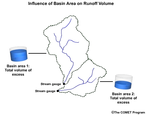
Conceptual graphic showing larger and smaller watersheds, and relative runoff amount from each
|
|

credits:
Creative Commons Daquella Manera
copyright terms:
Creative Commons Attribution 2.0 Generic
description:
Aerial view of rural, semi-arid Arizona, USA showing small shrubs and trees outlining basin waterways and features
|
|
|
|
|
|
|
credits:
©The COMET Program
copyright terms:
COMET Standard Terms of Use
description:
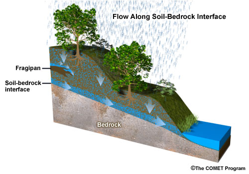
Graphic showing subsurface storm flow along a soil-bedrock interface.
|

credits:
©The COMET Program
copyright terms:
COMET Standard Terms of Use
description:
Graphic showing the location of a caliche in a desert soil profile.
|
|
|
credits:
©The COMET Program
copyright terms:
COMET Standard Terms of Use
description:
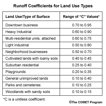
Land use type table for Rational Method Hydrologic Modeling method
|

credits:
©The COMET Program
copyright terms:
COMET Standard Terms of Use
description:
Cross-section showing effect of deforestation on runoff, groungwater and sediment transport.
|

credits:
©The COMET Program
copyright terms:
COMET Standard Terms of Use
description:
Graphic showing the influences of depth-to-bedrock on runoff.
|

credits:
NOAA / NWS / The COMET Program
copyright terms:
COMET Standard Terms of Use
description:
Example of distributed data grid on basin.
|

credits:
NOAA / NWS / The COMET Program
copyright terms:
COMET Standard Terms of Use
description:
Comparison of distributed data for precipitation and surface runoff on a grid on a basin.
|
credits:
NOAA / NWS / The COMET Program
copyright terms:
COMET Standard Terms of Use
description:
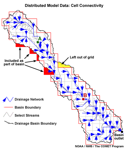
Distributed data showing cell connectivity in a grid on a basin.
|

credits:
USGS / Photo by John A. Moody
copyright terms:
COMET Standard Terms of Use
description:
Incised channel after the Cerro Grande Fire near Los Alamos, NM
|

credits:
(c)The COMET Program
copyright terms:
COMET Standard Terms of Use
description:
Flowchart of steps in the flood prediction process
|
|
|

credits:
©The COMET Program
copyright terms:
COMET Standard Terms of Use
description:
Graphic showing the influence on runoff and groundwater caused by layers of low permeability within the soil profile.
|

credits:
©The COMET Program
copyright terms:
COMET Standard Terms of Use
description:
Interactive diagram showing general components of a complex hydrologic forecast system.
|

credits:
NASA
copyright terms:
COMET Standard Terms of Use
description:
Global map of soils showing the fraction of clay contained in the top two centimeters of soil
|

credits:
NASA
copyright terms:
COMET Standard Terms of Use
description:
Global map of soils showing the fraction of sand contained in the top two centimeters
|

credits:
NASA
copyright terms:
COMET Standard Terms of Use
description:
Global map of soils showing the fraction of silt contained in the top two centimeters of soil
|
|
|
|
|

credits:
©The COMET Program
copyright terms:
COMET Standard Terms of Use
description:
Depiction of basic soil water and runoff terms: infiltration, baseflow, interflow, and surface runoff
|
|
|
|
|
|
credits:
NOAA / NWS / The COMET Program
copyright terms:
COMET Standard Terms of Use
description:
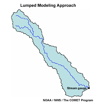
Basin showing lumped modeling method.
|
credits:
©The COMET Program
copyright terms:
COMET Standard Terms of Use
description:
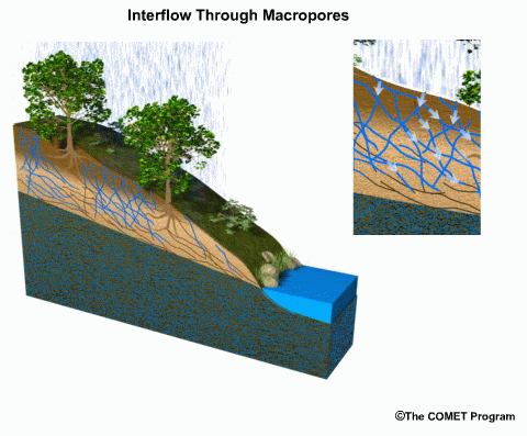
Animation showing how tranmissivity feedback through "macropore" networks can enahnce strom runoff beneath the soil surface.
|
credits:
Image courtesy of FISRWG
copyright terms:
COMET Standard Terms of Use
description:
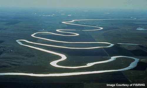
Photo of highly sinuous (meandering) river with a very extensive floodplain.
|
credits:
©The COMET program
copyright terms:
COMET Standard Terms of Use
description:
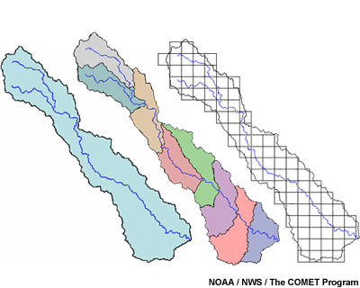
Montage of lumped, semi-distributed and distributed basins.
|

credits:
Photo by Lynn Betts, USDA / NRCS
copyright terms:
COMET Standard Terms of Use
description:
Photo of urban sprawl, Las Vegas, Clark County, NV.
|

credits:
Photo by Kathy Hoppe, Maine Department of Environmental Protection
copyright terms:
COMET Standard Terms of Use
description:
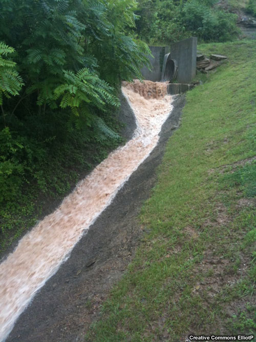
Water running off of a parking lot.
|
|
|

credits:
©The COMET program
copyright terms:
COMET Standard Terms of Use
description:
Illustration of approach used in the Rational method.
|

credits:
©The COMET Program
copyright terms:
COMET Standard Terms of Use
description:
General Runoff Processes: International Edition for both rainfall and snowmelt within a basin, including both surface runoff and interflow.
|
|

credits:
©The COMET Program
copyright terms:
COMET Standard Terms of Use
description:
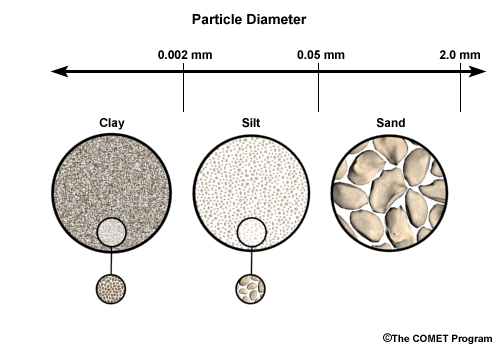
Comparison of pore space in sandy soil versus clay soil. A zoomed image shows larger spaces existing between large, irregularly shaped particles of sandy soil. The zoomed image of clay soil shows small spaces between many small, round clay particles.
|
|

credits:
USGS / Photo by John A. Moody
copyright terms:
COMET Standard Terms of Use
description:
Channels draining burned areas have zones of erosion and zones of deposition. This deposition occurred downstream from the erosional zone shown in the previous photo. The peeled bark indicates the highest level of water and debris during a flash flood. Sediment is coarse sand and gravel. The view is downstream and the blue backpack is about 1 meter tall. Photo by John A. Moody
|
credits:
NOAA / NES / The COMET Program
copyright terms:
COMET Standard Terms of Use
description:
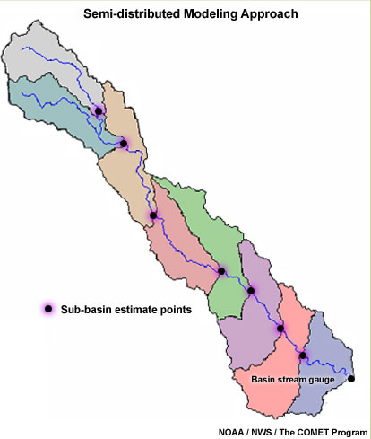
Basin showing semi-distributed modeling method.
|
|
|

credits:
©The COMET Program
copyright terms:
COMET Standard Terms of Use
description:
Soil cross-section schematic showing soil horizons.
|
|
credits:
©The COMET Program
copyright terms:
COMET Standard Terms of Use
description:
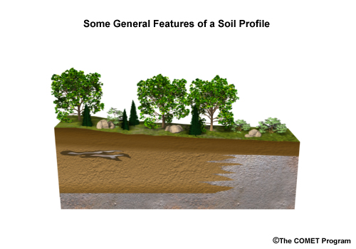
Graphic showing the different basic characteristics of a soil profile.
|
|

credits:
USDA / The COMET Program
copyright terms:
COMET Standard Terms of Use
description:
Soil triangle showing relationship between various soil textures.
|
|
|
|
|
credits:
©The COMET Program
copyright terms:
COMET Standard Terms of Use
description:
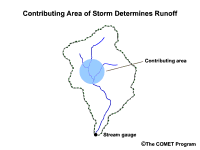
conceptual graphic showing smaller storm footprint than size of watersheds
|
|

credits:
©The COMET Program
copyright terms:
COMET Standard Terms of Use
description:
Graphic showing concept of subsurface stormflow , or interflow
|
credits:
©The COMET Program
copyright terms:
COMET Standard Terms of Use
description:
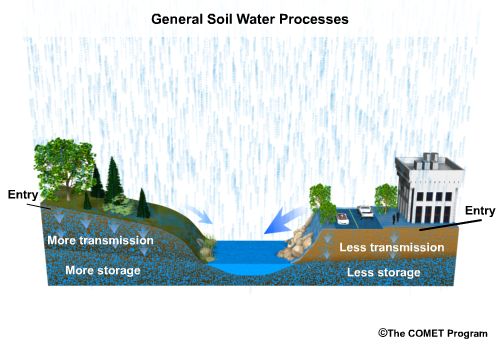
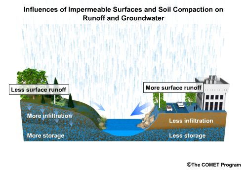
Cross-section showing effect of urban surface cover vs. natural forest on runoff.
|

credits:
©The COMET Program
copyright terms:
COMET Standard Terms of Use
description:
Depiction of two types of surface runoff: infiltration excess and saturation excess overland flows.
|
credits:
©The COMET Program
copyright terms:
COMET Standard Terms of Use
description:
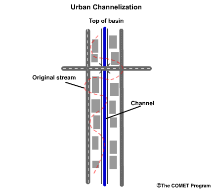
Illustration of the effect of straightening and channelizing a stream in an urban setting.
|

credits:
©The COMET Program
copyright terms:
COMET Standard Terms of Use
description:
Illustration of the effect of urban concrete grid on runoff contribution to stream in a basin.
|
|
|

credits:
©The COMET Program
copyright terms:
COMET Standard Terms of Use
description:
Depiction of sub-basins formed by road across a basin.
|


