|
|
AIR POLLUTION IN THE CZECH REPUBLIC IN 2007 Czech Hydrometeorological Institute - Air Quality Protection Division |
|
|
|
|
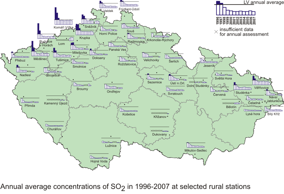
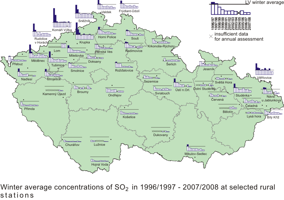
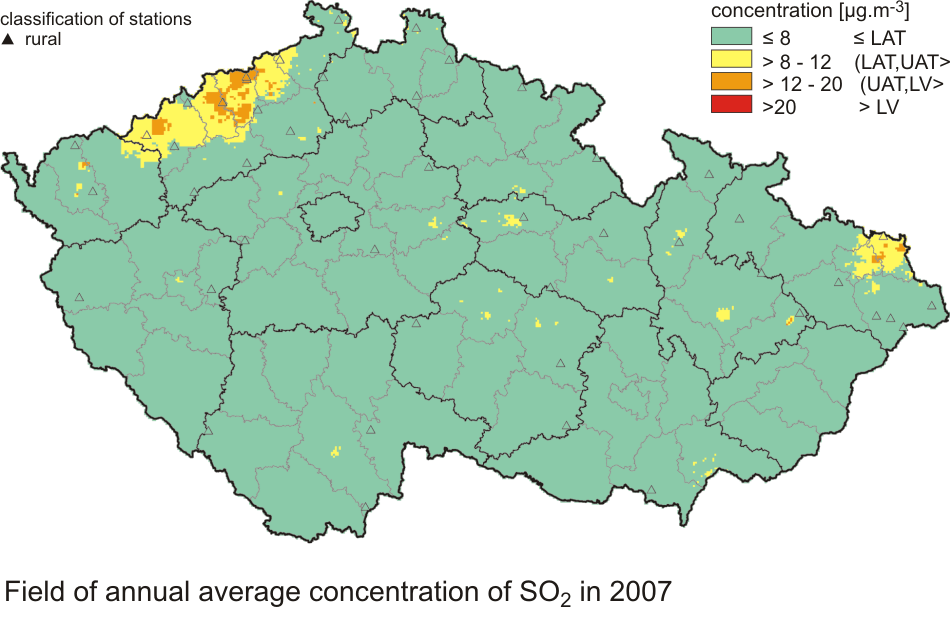
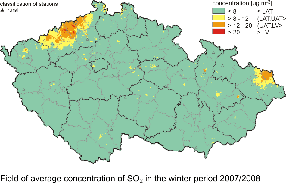
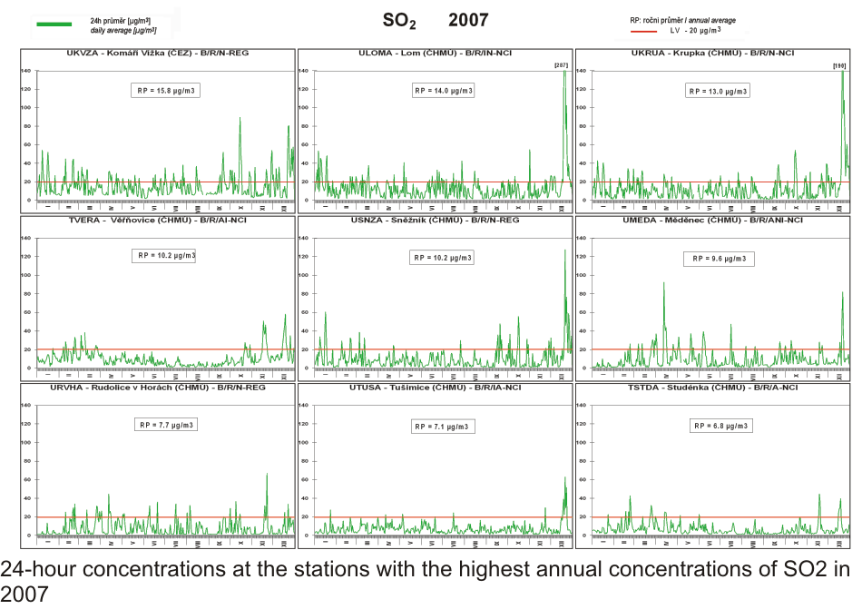
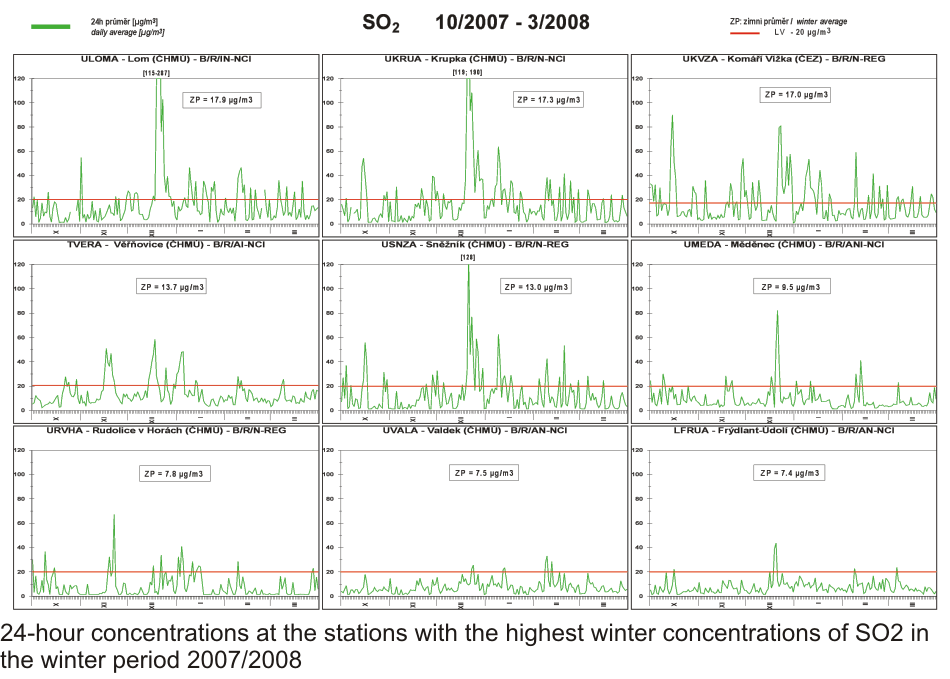
II.4.2.2 Air quality with regard to the limit values for the protection of ecosystems and vegetation In addition to the limit values for the protection of health the national legislation introduced, in compliance with EU Directives, also the limit values for the protection of ecosystems and vegetation. The survey of the limits is presented Chapter II.3. II.4.2.2.1 Sulphur dioxide Fig. II.4.2.48 demonstrates the significant improvement of air quality with regard to sulphur dioxide after 1997 in connection with coming into force of the Act No. 309/1991 Coll. and meeting the set emission limit values by the end of 1998. Since then the annual averages of SO2 have not exceeded the set limit value 20 μg.m-3 at rural stations. In 2007 there was further significant increase of air pollution caused by SO2 on the whole territory of the Czech Republic due to favourable meteorological and dispersion conditions. In the winter period 2007/2008, due to favourable dispersion conditions, air pollution caused by SO2 decreased at most stations as compared with the previous period of 2006/2007. In the localities of the Ústí nad Labem and Moravian-Silesian regions the level of air pollution was roughly comparable (Fig. II.4.2.48). The maps in Figs. II.4.2.49 and
II.4.2.50 also evidently show that rural
localities did not exceed the limit value both for the 2007 annual average
concentrations and for the winter average concentration in the winter period
2007/2008. The limit value (20 μg.m-3) was exceeded only in a few
small areas in the districts Most and Teplice. The maps were constructed from
the data of all the stations measuring SO2 with the significance (weight)
according to their classification; only rural stations are marked with spot
symbols. Tab. II.4.2.21 Stations with the highest values of annual average concentrations
at rural stations, SO2 Fig. II.4.2.47 Annual average concentrations of SO2 in 1996–2007
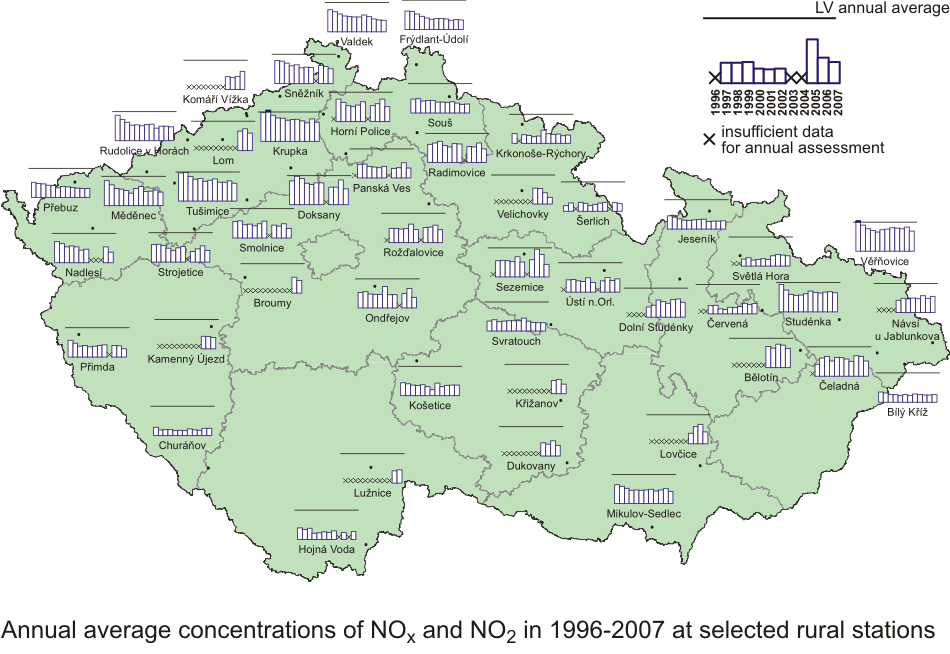
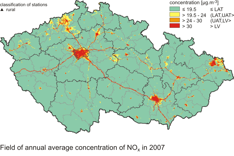
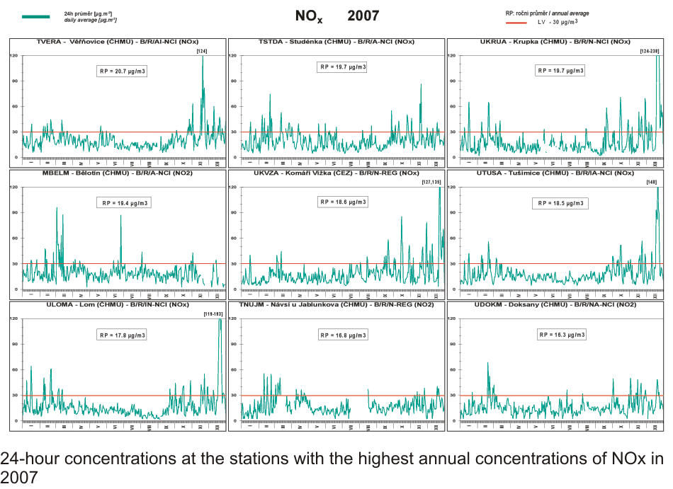
at selected rural stations II.4.2.2.2 Nitrogen oxides In 2007 annual average NOx concentrations decreased at most rural stations (Fig. II.4.2.53). As it is evident from the map in Fig. II.4.2.54, rural localities did not record the exceedance of the NOx concentration limit value for the protection of ecosystems and vegetation in 2007. The construction of the map of the spatial distribution of annual average NOx concentrations is based on the combination of measurement and modelling results and also national traffic census from the year 2005 was regarded; as compared with the previous census in 2000 the increase of traffic is significant. The higher NOx concentrations can occur also in the vicinity of local communications in the villages with intensive traffic and dense local transport network, where there is no measurement of concentrations. For the construction of the map of the field of NOx concentrations all stations measuring NOx were used, including the rural stations measuring NO2. The spot symbols highlight only the rural stations. This chapter is closed by the graphs of courses of 24-hour NOx concentrations at selected stations, related to the limit value for the annual average (Fig. II.4.2.55). Fig. II.4.2.53 Annual average concentrations of NOx and NO2
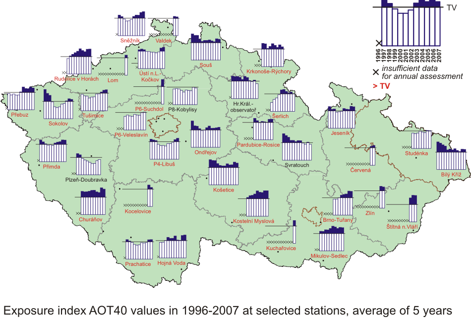
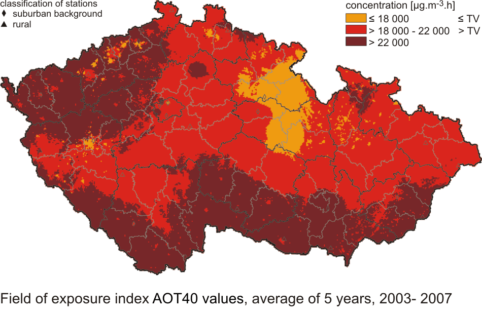
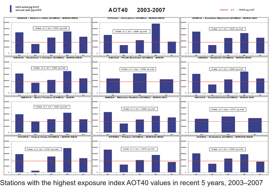
in 1996–2007 at selected stations II.4.2.2.3 Ground-level ozone Of the total number of 36 rural and suburban stations for which the AOT40 calculation is relevant according to the legislation, the target value for ozone for the protection of vegetation was exceeded at 32 localities in 2007 (the average for the years 2003–2007). As compared with the previous assessment for the period 2002–2006, the situation has not markedly changed. The temperature for the period from which the AOT40 exposure index is calculated (May–July 2007) was by 0.3 �C lower than that in the year 2002, which has been already excluded from the five-year assessment. The most significant decrease of AOT40 values was recorded on the territory of the Hradec Králové and Pardubice Regions (localities Hr. Králové-observatoř and Svratouch), which reached below the target limit value. As for the measured concentrations in the localities, it can be stated that the number of the localities with the increase of the AOT40 exposure index was slightly higher than the number of localities with its decrease. The spatial distribution of AOT40 exposure index for the 2007 assessment is shown in the map in Fig. II.4.2.57. Fig. II.4.2.58 presents the AOT40 development in 2003–2007 in selected stations. Tab. II.4.2.24 Stations with the highest AOT40 values of ozone at rural and suburban stations Fig. II.4.2.56 Exposure index AOT40 values of ozone in 1996–2007 at selected
stations, average for 5 years
|